Death Valley and the Alabama Hills

It was a fall afternoon when a day
of wandering and driving ended up in Lone Pine, a beautiful California town with
views of the steep granite face of Mount Whitney. Western movies loved the
steep slopes and the tawny Alabama Hills that lead up to the trails into the
southern Sierra. Light is kind to these rock formations. Sharp shadows are cut
in morning sun offering a dramatic backdrop. Lone Pine is still a movie
festival destination, celebrated as the location for dozens of Westerns.
I’m
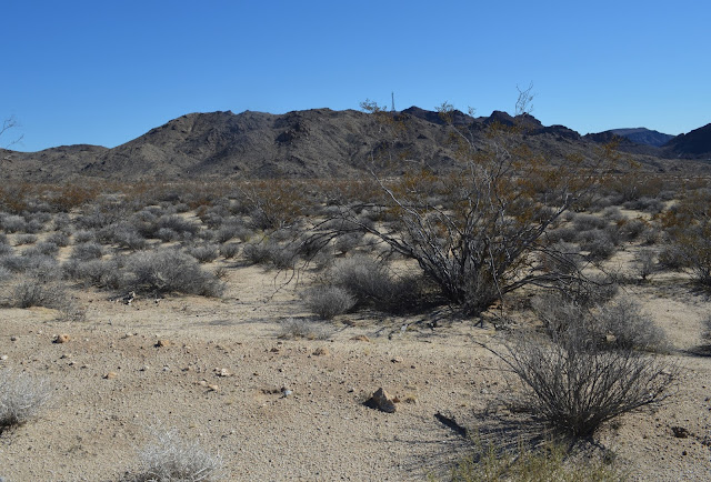
heading east, from Olancha into the vast badlands that precede the Panamint
Range and then Death Valley, if I make it that far. Traveling to Death Valley
in the late afternoon by automobile isn’t a particularly dangerous adventure.
But it feels that way as I pull up the grade, chugging the Jeep into steep
ravines of black rock and glimpses of the upper Panamint Valley that stretch
dozens of miles.
Panamint Springs is an outpost. A
café and General Store, gas station and a few motel cabins. It’s a few miles
from the bottom of the Panamint Valley floor. The view there is spectacular.
The silence is even more memorable. Over an hour since leaving Olancha, and
I’ve seen hardly any cars, and only one or two have pulled up at the Springs.
Desert silence is a bonus that nature throws in after adventuring into what is
almost forbidden territory. No animals, no hawks or blackbirds, no insects ride
these desert heights and if they do roam here, they stay hidden even in the
relatively mild heat of late autumn. Crashing surf in Santa Barbara, the whistle
of wind on Lake Tahoe pine, or the rushing streams of the Eel River or the
Feather caress your skin, ears, and your soul. Lake Tahoe gleams like a blue gem
cut from a jeweler’s chisel, surrounded by a diamond setting of snow-capped
Sierra peaks. On the Pacific coast, waves roll in from a horizon of pink
sunsets like cocktails served up nightly on the veranda. Trout and eagles,
hawks and bear make their homes in the central Sierra and Coast Ranges, sharing
space with humans who travel the trail and wade into the streams. They’re
tactile clues that nature envelops you, and wants you to notice.
The
Panamint doesn’t utter a word of welcome. Nobody answers the door when you
knock. Sound isn’t merely deadened. It doesn’t exist. Perhaps the rock sucks up
vibration and swallows all sound. Maybe there is no sound. What makes it
uncomfortable for many people isn’t that it’s quiet and empty. It’s that you
have to listen to yourself. You strain to pick up inner vibrations, tune into
mortal thoughts, or hallucinate into believing that you have no thoughts and
those that stream into your head are false clues from a distrusted source.
Silence creates doubt. And when preceded by doubt, fear isn’t far behind.
I
drop a few dollars on the counter for a soda and snacks. The store clerk gives
me approximate mileage to Stovepipe Wells.
“Thirty
miles,” he says. “Good road. About 25 miles from Stovepipe to Furnace Creek”
Highway
190 sweeps down the rocky grade from Panamint Springs up into the Panamint
Range, topped by Telescope Peak at over 11,000 feet. On the other side of the
Panamint is Death Valley. The mileage, while only a little over fifty miles,
feels like a transition into another time zone, or maybe the distance from the
earth to the moon, light years, galactic millennia, eons, something like the
gap between the Mesozoic and the Pleistocene eras, measured in millions of
years. Familiar road signs that cover the state of California from the Pacific
Ocean to the great cities of Los Angeles, San Francisco and San Jose and the
highways crossing the state from Lake Tahoe to Yosemite to San Diego are
missing. No billboards reminding you to stop for a Big Mac, 24-hour breakfast,
where the Motel 6 is waiting for you. Gone are the cute signs for rest stops,
lodging and food.
If
the beaches are the glamor of the state, the cities the hubs, the Sierra the
crown, and Yosemite and Tahoe the jewels, Death Valley is the tomb, the crypt,
the cemetery, the bowels, hindquarters, butt, the rear ends nobody wants to explore.
Not only does Death Valley feature the most extreme elevation change from the
high ridges of the Panamint and Telescope Peak to Badwater, the geology is
other-wordly. The earth’s crust literally cracks apart down in the valley floor.
Temperatures so hot the heat splits the earth
and pulls it apart around an inch every five
years. If Santa Monica beach seems fresh from a recent nip-tuck from a
Hollywood plastic surgeon, Death Valley is a festering wound that never heals.
Your
cell phone won’t work. Radio stations aren’t available. Most of the familiar
and comforting guides to road travel are gone. My Jeep didn’t have a GPS
system. All I have are traditional maps, and limited daylight.
My
Jeep is normally stocked with overnight supplies. Blankets and sleeping bag,
water, light food, compass, knives, flashlights. I won’t die. I’ve hiked and
camped overnight in Jackson Hole, in the Rocky Mountains of Colorado, the beach
at Puerto Penasco, Mexico, the high Sierra of Yosemite.
I
give the Jeep more gas on the upslope of the Panamint Range, ease off the pedal
in the turns, tilt the vehicle down the last grade, straight as an arrow, into
the northern plain of Stovepipe Wells and Death Valley.
To
all the iconic beauty of California, Death Valley provides a stark contrast.
The Valley is a geologic masterpiece every bit the equal of Yosemite and Lake
Tahoe. It’s bare and raw, compared to the majesty of the Pacific Ocean and the
forests of the Sierra. Yosemite’s high country granite is sculpted into a sheen
that plays with snow so crystalline it sparkles in any light. Death Valley is
harsh and vast, severe and frightening, punishing with blast furnace summers
and lack of available services.
It’s
Mars to the rest of the Golden State’s sublime Venusian splendor.
It
kicks your ass, while beaches soothe your Hollywood ego.
It
tells you to go away. The rest of the state begs you to stay.
Disneyland,
Magic Mountain and Universal City don’t have Death Valley feature rides that
offer the visitor a deadly taste of sunstroke, dehydration, eyeball-melting
heat, disorientation, and a sun so relentless it wins the battle against the
earth’s surface crust.
You’ll
love it, or you’ll hate it. But be warned. You’ll never be the same once you’ve
been there. You might skip future trips and choose the Grand Canyon, Sedona,
the Colorado River snaking through the oasis of the Parker Strip, water skiing
on Lake Havasu or Lake Powell, but Death Valley leaves an imprint on your soul
you’ll not outlive. That’s what Hell is meant to do.
The
point of no return is a concept almost forgotten in today’s world. It’s
frequently used in hiking, when you decide how far you’ve gone and realize it’s
going to be just as long (or longer, depending on terrain) to make it back to
the trailhead. If you’re on a loop trail, you’ll know the approximate half way
point and gauge your hiking accordingly. Keep going on the loop, and you’re
closer to your vehicle. On a one way trail, you’ll either go back the way you
came or seek a suitable location to pitch a tent and spend the night.
On
the road the stakes are a little different than on the trail. You travel
faster, cover more miles in less time. There might be suitable lodging up ahead
if you just keep driving. Approaching the Panamint Range (the range just to the
east of Panamint Springs) you’ll be in twisting roads for a few miles, and
descend down a straight grade into the northern tip of Death Valley to the park
entrance at Stovepipe Wells. Camping spaces might be available at Stovepipe,
but services are limited. You are also two to three hours from the nearest
towns; Olancha and Trona to the west, and Shoshone on the eastern side of the
valley. Options are limited in any direction you travel. Fall, winter and early
spring offer the best climate to travel. You’re not likely to encounter 100
degree days. I descend.
Highway
190 is dead straight from the top of the Panamint Range down into Stovepipe
Wells. Trucks with camper shells, RVs, motorcycles and cars form a slow moving
pack train moving up the grade westbound from the park. You might get a wave, a
honk, a blink of headlights from oncoming drivers signaling your shared passion
for wild spaces.
The
ranger station at Stovepipe Wells is closed. Only the restroom is open. A kiosk
offers a map and guide to the park and informs you to pay entrance fees at
Furnace Creek, where park headquarters is located. Torn ridges of the Funeral
Mountains and the Grapevines cut the horizon into shades of dusty mocha and
pink against the faded blue sky. Two motorcycles that have been following at a
distance down the long grade pull in. The riders wave at me. One is riding a
BMW touring bike, the other a Kawasaki Versys 1000, a new hybrid model that
combines the ruggedness of an off-road dirt bike together with the more refined
manners of a touring machine. Seeing these guys in my mirror for a few miles,
and now at the entrance station gives me a feeling of comradery. I don’t feel
so alone in the deep abyss of the park. Someone else has ridden into the cleft.
At just after 3:00 PM, I have at least five hours of driving to get home, and
only two hours of daylight left.
The
dunes shine in the afternoon sun, large humps of gold dust shape-shifting at
all hours of the day. They’re beautiful, and far enough away so that I can’t
get a good photograph. I head further into the park and stop to get gas at
Furnace Creek.
The
two motorcycle riders are gassing up their bikes and we exchange notes. He likes
the Versys, and the BMW rider says they pushed their bikes in the swerves
between the dunes and Furnace Creek.
“Gave
that guy a run,” he says, pointing to a Ferrari at another pump, low and red,
capable of fast sprints to outrun the law.
With
the sun hanging over the Panamint Range to the west, I’ve got several hours of
twilight and night time desert driving to get home. My spontaneous desert ride
has left me with no motel reservations, and hours of driving to find decent accommodations.
Sleeping in the Jeep is an option but I’d need a camping spot in the park. Nothing
is available.
Sunlight
vanishes behind the Panamint Range, leaving sun streaks through broken clouds
over the southern Sierra. Purple sage, magenta quartzite and rusty soil all
glow in the dusk. The Jeep hugs curve after curve, up and over the mountains in
the cool evening air. It is dark at the intersection of 190 and Panamint Valley
Road heading south to Trona and Ridgecrest.
Driving
Panamint Valley Road with only starlight high above is a mind game after hours of
wandering through Death Valley. The road comes alive in the dark and triggers
sensory overloads that play tricks with the imagination. Side guards glitter in
the headlights, the road bending into wide S turns that you feel when the Jeep
pulls side to side. Behind the phosphorescent strips lining the guard rails, darkness
creeps from the banks of the desert’s walls and up-up-up to the heavens, masking
the hills and swales, the narrow shoulders that provide no safe space if the
Jeep skids off the pavement. The Jeep pulls up a grade but I see no indication---on
the road or from the guard rails---of an incline. It’s driving by feel. Gripping
the wheel, watching headlights sweep the tarmac and recede against the reflective
pylons. When the road drops back into the valley and straightens, I feel the
Jeep level out onto the even stretch of highway. And I’m not alone.
Headlights
appear in my mirror far back in the night. Up ahead another light shines from
miles away, or maybe a few hundred yards, or maybe my eyes are demanding light
to guide me through this forbidden journey. Reference points don’t exist.
Highway signs are non-existent. The Jeep is a spacecraft and I’m without GPS,
no radar, no altimeter, only the gas pedal and steering wheel providing tactile
signals from the road. Behind me the headlights are steady. My mind searches
the possibilities of the single source of light ahead in the distance. Vehicle?
Road sign? A rest stop up here at night could be a dangerous place to pull
over, but who’s driving this deserted desert stretch besides me and whatever is
behind me? UFOs? Not too far to the southwest is the China Lake Naval Weapons
Range and all kinds of beastly ordnance explode down there.
Two
lights like low stars on the horizon, one in front and one in back, tracking me
through my ghostly passage. My only option is to keep driving. Trona is less
than thirty miles, Ridgecrest ten miles beyond that. The lights in front and
behind seem to get no larger, no more distinct. It’s as if the further I drive,
I make no progress toward the beacon. It taunts me, pointing a finger at me and
waves but moves further away. Behind me the headlights track with a steady
ferocity, never gaining, never receding, as if gravitational pull keeps us in
stationary orbit.
The
single light ahead splits into two, a truck rumbles by heading north. Another
light appears to the left, a pumping station squatting on a dirt road off the
highway. The mineral processing plant in Trona rolls into view on the last
stretch of lonely highway. Three or four stories of catwalks, infrastructure--the
exoskeleton of the plant--wired like a giant Christmas tree glowing in yellow
light. My spaceship has arrived at the mother ship, at the base of a spindly
maze of conveyor belt ramps, great humps of soda ash like mountains of the moon.
My interplanetary journey is nearing the end.
On
the outskirts of Trona looking down the final grade into Ridgecrest, an ancient
Mustang pulls up behind me. The Mustang veers out from behind me and swerves
back into the lane in front of me. I blink my headlights in acknowledgment of
our shared re-entry, a bleary-eyed nod to a fellow traveler, a prayer that his
lurching Mustang isn’t being steered by an inebriated driver. I need a beer.

Comments